3D LASER SCANNING AND MODELING SERVICES IN ANGOLA
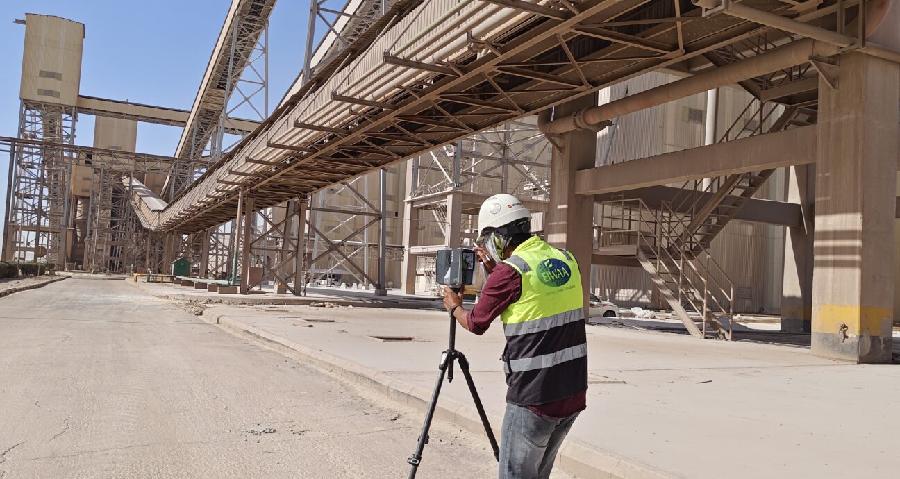
EIWAA Oil and Gas Services provides 3D laser scanning and modeling services in Angola through LiDAR scanning, 3D mapping and surveying and 3D imaging of structures, heritages and architectural building. Building integrity assessment and structural condition assessment is evaluated by using laser scanning and 3D reality capture services. We are one of the 3D Scanning company in angola provides 3D Laser scanning Services with Photogrammetry Services, LiDAR Scanning Services,3D Rendering, Laser measurement services,3D Reality capture Services, Spatial Scanning,3D Mapping and Surveying and 3D Modeling in Luanda and soyo .As one of the top 3D laser scanning companies in Angola, we are using Unmanned Aerial Vehicles (UAVs)/Drones, photogrammetry, 3D scanning laser measurement and advanced LiDAR scanning services for our digital surveying and 3D mapping services. We offer ground-level scanning either by using high-definition laser scanning and terrestrial data collection services. To gather high-resolution spatial data on the earth’s surface and structures, our ground LiDAR services use LiD AR methodology at ground level and is known as Spatial Scanning Services. For asset management, property management, inspection, and maintenance in Angola’s oil and gas, power plant, and refinery sectors, EIWAA provides 3D scanning services. By saving time and precise measurements, our scanned geographical data dramatically lowers project costs for urban planning, devolution, environmental monitoring, and cultural heritage protection.
LiDAR SCANNING SERVICES IN ANGOLA
Our LiDAR scanning services in Angola, which include laser scanning, 3D LiDAR surveying, LiDAR mapping solutions, point cloud surveying, and more, are mostly relied upon by the construction and oil field sectors. In addition to 3D scanning and modeling, we provide topographic LiDAR services and laser distance measurement for high-definition laser surveying. We are one of the LiDAR scanning companies in Angola that also provides 3D imaging services in addition to LiDAR mapping. We are a LiDAR mapping company in Angola that offers geospatial analysis, point cloud services, and remote sensing. LIDAR scanning and 3D modeling services are widely used in architectural engineering construction to enhance the design, construction, and upkeep of buildings and infrastructure. For laser measurement services, Asbuilt drawings, Asbuilt surveys, Asbuilt documentation, and integrity assessment services for structural analysis and bridge structural inspection, LiDAR scanning is the best non-contact dimensional measurement technique. The following advantages are offered to our clients by our 3D imaging and LiDAR scanning services for bridges and mountains:
- A precise, comprehensive, and accurate structural analysis of bridges
- Compared to traditional engineering survey services, LiDAR scanning services are faster and may cover more complex or huge areas.
- Mapping the topography of mountains and bridges
- Real-time monitoring
- 3D imaging services
- 3D surveying and mapping
- LiDAR environmental monitoring services
3D Laser Scanning
LiDAR Scanning
3D Modeling
3D Imaging
3D Mapping and Surveying
Photogrammetry
3D MAPPING AND SURVEYING IN ANGOLA
Our 3D mapping and surveying services in Angola include a broad range of fields, including geography, architecture, construction, urban planning, and environmental monitoring. Using 3D models, 3D mapping services in Angola create realistic visual representations of actual environments. Digital mapping and surveying services use Unmanned Aerial Vehicles (UAVs)/Drones, 3D scanning, photogrammetry, and 3D imaging technology. This is the most cutting-edge non-contact 3D scanning service currently offered in Angola. Our services for 3D mapping and surveying will be,
- Gathering and analyzing geographic and spatial data is known as "spatial data surveying and mapping."
- Remote scanning and non-contact scanning services are included in virtual surveying and mapping.
- Using the earth's surface as a 3D representation, digital terrain modeling
- Remote sensing and mapping: gathering data remotely using sophisticated scanners and sensors;
- Geographic information system: gathering, analyzing, and visualizing spatial data
- Geospatial Mapping: Creating Static and Topographic Maps using Spatial Data Analysis
BUILDING CONSULTANCY SERVICES IN ANGOLA
For civil condition assessments and remaining life assessments of buildings, bridges, and structures, we offer project management and building consulting services. Ultrasonic pulse velocity testing, rebar scanning and detailing, acoustic emission testing, thermal imaging, and thermography survey services are among our non-invasive concrete inspection and concrete structural analysis by NDT inspection services. Core cutting, wall scanning, carbonation depth measurement, half-cell potential, and slab cutting are the methods used for structural evaluation services through destructive testing. International ACI 562, ACI 563, and BSI 6089 standards must be followed while providing concrete strengthening and testing services.
FREQUENTLY ASKED QUESTIONS
Alfa Lavel and Mistubishi lubrication system-MALS are the major customers of EIWAA Marine for retrofitting Hull lubrication system of vessels to achieve Decarbonization at Marine and shipping industry.
Shipbuilding laser scanning services to Facilitate efficient shipbuilding processes by utilizing our laser scanning services for accurate measurements and documentation. Restructuring and extending industrial plants with laser scanning. Refinery scanning services to Optimize refinery operations and maintenance with our laser scanning services tailored for refineries and Power plant scanning using laser technology.
Air bubble lubrication system in ship is an energy saving technique by reducing the resistance between ship’s hull and sea water using air bubbles which in turn reduces the CO2 emission rate. EIWAA has numerous proven track records of scanning and CAD modeling of Hull lubrication system for ships and Vessels.
Clash detection with laser scanning to Identify and resolve clashes in complex structures and layouts by utilizing our precise laser scanning technology. Piping routing using laser scanning to Optimize piping systems by leveraging the accurate measurements obtained through laser scanning. Equipment positioning with laser scanning and Space management to manage space utilization and layout planning through our laser scanning solutions.