
STOCKPILE SURVEY SERVICES IN ANGOLA
For stockpile measurement surveys, aggregate quantity surveys, earthworks surveys, volumetric surveys, and storage tank dimensional surveys using laser measurement services in Luanda and Soyo, EIWAA is one of the best stockpile survey companies in Angola. In Angola, EIWAA Oil and Gas Services is the company that offers laser measuring services for stockpile measurement surveys, aggregate quantity surveys, earthworks surveys, and stockpile quantity surveys. The best quantity survey service in Angola for earthwork surveys, stockpile volume surveys, and stockpile quantity surveys is EIWAA Stockpile Survey Services by Laser Measurement. Survey of stockpile quantity In Angola, services include precise measurements and as-built surveys of minerals, coal, or aggregates. We offer stockpile measurement surveys using LiDAR 3D laser scanning and GIS survey for precise stockpile quantity surveys in Angola. In order to conduct the Earthworks Survey and Stockpile Measurement Survey, precise scanners, LiDAR scanners, and terrestrial scanners equipped with advanced 3D modeling software are required.The integration of GIS and LiDAR scanning technology enables more accurate and efficient estimation and quantity surveying services for earthworks projects.
AGGREGATE QUANTITY SURVEY SERVICES
Our aerial geophysical measurement services and remote sensing capabilities, which are used to map and locate exposed bedrock units and surficial deposits, should be utilized to investigate the geographic location and distribution of potential natural aggregate deposits. Aerial surveys have been used to map superficial deposits based on physical variations in resistivity controlled by porosity, permeability, and the enclosed fluids. The data derived from these digitalized observations comprise both spatial information defining the surface features and compositional data based on physical parameters. LiDAR remote sensing equipment collects digital measurements, which are then processed, analyzed, and interpreted by computers before being easily included into Geographic Information System databases.
Remote Sensing measurement
Geophysical measurement
Digital Measurement
3D Mapping and Surveying
Laser Measurement
Volume Calculation
EARTHWORKS SURVEY SERVICES IN ANGOLA
Our aerial geophysical measurement services and remote sensing capabilities, which are used to map and locate exposed bedrock units and surficial deposits, should be utilized to investigate the geographic location and distribution of potential natural aggregate deposits. Aerial surveys have been used to map superficial deposits based on physical variations in resistivity controlled by porosity, permeability, and the enclosed fluids. The data derived from these digitalized observations comprise both spatial information defining the surface features and compositional data based on physical parameters. LiDAR remote sensing equipment collects digital measurements, which are then processed, analyzed, and interpreted by computers before being easily included into Geographic Information System databases.
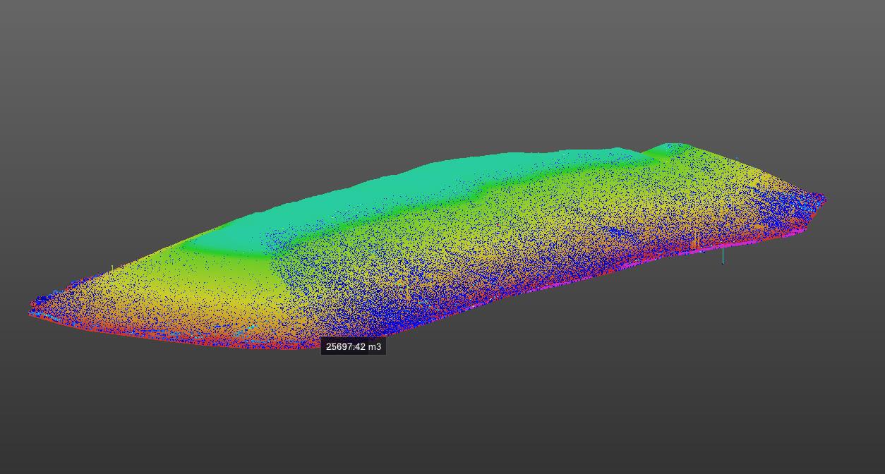
VOLUMETRIC SURVEY SERVICES IN ANGOLA
We are a finished products survey company in Angola that specializes in stockpile volumetric survey services. We also set up survey control stations and conduct survey reconnaissance of the entire stockyard. We use a 3D laser scanner for our volumetric survey of bulk cargo in power plants. This allows us to identify the cargo for each stockpile and calculate the cargo volume survey services for each stockpile based on the cargo density. High free lime, sand, normal clay, white clay, iron ore, and limestone are all included in the volumetric survey of physical stock measurement services for clinker and other raw materials.
LASER MEASUREMENT SERVICES
Storage tank peaking/banding surveys, verticality checks and measures, roundness surveys, ovality measurements, and more are all included in our laser measuring services in Angola. By employing EODR laser measurement techniques, laser scanning solutions and LiDAR scanning technologies can offer laser measurement services. It is a non-contact, remote sensing method for measuring the dimensions of any kind of fuel oil storage tank, including those with fixed roofs, internal floating roofs, and floating roofs.