3D Scanning
EIWAA Marine is your trusted marine scanning service provider for 3D Laser Scanning Service and 3DModeling of ships, vessels and offshore rigs. EIWAA is your retrofitting and engineering solution of2nd Generation Hull Air Lubrication System, BWTS (Ballast Water Treatment System), EGCS (Exhaust Gas Cleaning System), Chiller System, Scrubbers, etc. Major scopes of Marine laser scanning services includes BWTS Scanning, Hull Air Lubrication 3D Scanning, Ballast water treatment scanning, Vessel Hull Scanning, Scubber unit installation etc.
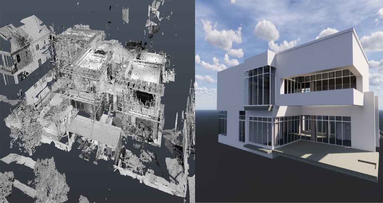
In Offshore laser scanning ,we are providing offshore Rig scanning Services and offshore structure scanning for subsea asset inspection as well as asset management solution. For as built documentation purposes, offshore sector scanning is a mandatory element and which in turn used for reverse engineering as well as retrofitting engineering. Ship Scanning Service provides accurate laser measurements for 3D Modeling by 3D Imaging and 3D Laser Service.
Laser scanning services at marine and offshore
EIWAA Marine Survey Services offers Accurate and detailed laser scanning services tailored for the marine & offshore industry by Offshore laser scanning, Rig scanning services, BWTS scanning, Reverse engineering scanning, Marine vessel hull scanning, Offshore rig scanning, Offshore structure scanning, Subsea asset inspection, As-built documentation, Marine industry scanning and Offshore sector scanning.
- Rig Scanning
- Offshore Laser Scanning
- Reverse Engineering
- Offshore Structure Scanning
- Hull Scanning
Hull Air Lubrication
Ballast Water Treatment
Yacht and Boat
Why EIWAA Marine Engineering Services?
EIWAA Marine and Engineering offers 3D Laser scanning and accurate 3D Model of Hull Lubrication System (ALS) ,Ballast Water System(BWTS) and Exhaust Gas Cleaning Scrubbers(EGCS) with on time delivery and dealing with major marine suppliers and manufacturers of shipping industry. EIWAA is one of the best marine survey companies in UAE for providing LiDAR Scanning Services, 3D Scanning Services and Marine laser scanning services for all types of marine retrofitting and conversion engineering solutions.
- All Major Ports Approval
- IACS Approvals
- High Precision Scanning
- All Offshore approvals
Our 3D Modeling Services gives accurate results of laser measurement services and asbuilt engineering. Our Core Naval Architecture Services in marine retrofitting solution are 3D Laser Surveying Services of BWTS Scanning Services and Ballast water treatment system Installation, Hull Air lubrication system 3D Scan, EGCS Scanning etc. 3D Rendering Services and 3D Modeling Services covers the scope of Ship Sounding Services, Ship tank ullage survey services, Ship and Barge tank Calibration Services etc. Marine Services of 3D Scanning and Modeling Services are approved by Major IACS Classification societies and Major Ports of UAE.
Frequently Asked Questions
Alfa Lavel and Mistubishi lubrication system-MALS are the major customers of EIWAA Marine for retrofitting Hull lubrication system of vessels to achieve Decarbonization at Marine and shipping industry.
Shipbuilding laser scanning services to Facilitate efficient shipbuilding processes by utilizing our laser scanning services for accurate measurements and documentation. Restructuring and extending industrial plants with laser scanning. Refinery scanning services to Optimize refinery operations and maintenance with our laser scanning services tailored for refineries and Power plant scanning using laser technology.
Air bubble lubrication system in ship is an energy saving technique by reducing the resistance between ship’s hull and sea water using air bubbles which in turn reduces the CO2 emission rate. EIWAA has numerous proven track records of scanning and CAD modeling of Hull lubrication system for ships and Vessels.
Clash detection with laser scanning to Identify and resolve clashes in complex structures and layouts by utilizing our precise laser scanning technology. Piping routing using laser scanning to Optimize piping systems by leveraging the accurate measurements obtained through laser scanning. Equipment positioning with laser scanning and Space management to manage space utilization and layout planning through our laser scanning solutions.