3D LASER SCANNING IN QATAR
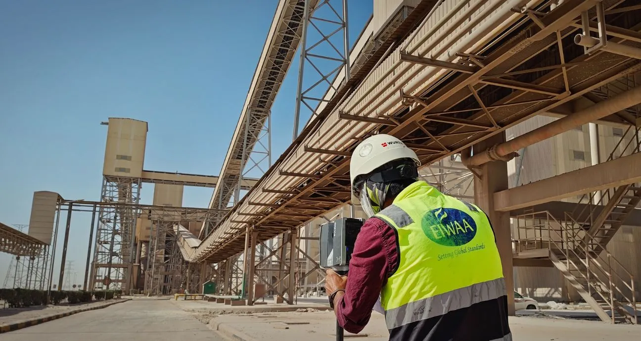
EIWAA is the right 3D laser scanning services in Qatar offers point cloud surveys, point cloud modeling, and point cloud scanning to enable 3D modeling in oilfields, petrochemical plants, and storage tank terminals. EIWAA is the best 3D scanning solution for 3D imaging, 3D mapping, digital oilfield solutions and oilfield mapping. Industrial laser scanning, as-built surveys, as-built documentation, spatial scanning, and reality capture measurements for buildings, civil and architectural companies, HVAC and MEP industries. Our 3D scanning specialists are proficient in point cloud modeling using Leica, Cyclone, Recap, and FARO Scene software. A single team for point cloud generation, point cloud scanning, registration, clash detection, and georeferencing of data, helps to reduce manual error and improves the quality of datas. Our 3D scanning survey specialists worked for onshore and offshore platform structures of Qatar Energy storage tank terminals, buildings, airports, hotels, and restaurants.
For accurate 3D Scanning survey solutions of Power plants, Processing plants, oilfield facilities, architectural buildings, and brownfield modifications/repairs, we are using advanced laser scanning solutions. Our 3D scanning experts capture millions of accurate laser measurement points within seconds to create HD laser scanning and 3D imaging of infrastructures, assets and industrial equipment. We provide accurate as-built drawings, 3D models, and as-built documentation to help HVAC companies, Electrical Companies, Building construction, and architectural engineering consultants.
3D SCANNING SPECIALIST IN QATAR
For oilfield laser scanning of refineries, petrochemical plants, power generating facilities, manufacturing plants, and process plants, we are the best 3D scanning specialists. The industrial laser scanning is a remote 3D surveying service that measures reality using laser beams. We compile the precise geometry of equipment assets, structures, and storage tanks. As a 3D scanning service provider, we offer the highest standard site data evaluation and replace a conventional engineering surveying assessment.
3D IMAGING IN QATAR
EIWAA is the best option for structural as-built drawings, BIM models, Revit models, AutoCAD models, Navisworks models, and digital twins if you’re seeking 3D imaging services in industries and oil fields. We offer expert site surveying reports along with 3D imaging services with the essential specifications of laser measurement survey reports and clash detection for equipment installation, retrofitting and reverse engineering.
REALITY CAPTURE MEASUREMENT IN QATAR
Conditional evaluations and real-time monitoring are made possible by laser scanning and reality capture measurements of assets and standardized buildings. Commercial buildings, industrial warehouses, airports, bridges, ports, roads and highways, and utility corridors are proof of infrastructure and building scanning measurements. We provide registered point cloud data, color photos, 2D CAD drawings, as-built drawings, and general arrangement drawings as deliverable of our reality capture measurement services.
3D SCANNING IN QATAR
Our 3D scanning survey services use a methodical workflow and its applications to meet your needs. We carry out as-built documentation, brownfield engineering projects, plant expansion and modification, asset integrity monitoring, and digital twin development for all infrastructure and commercial development.
- Brownfield Engineering Projects: By supplying precise scan data that allows engineers to create alterations of the highest caliber, we are reducing downtime, risks, and other possible dangers.
- As-built Documentation: For industrial assets where the current data and drawings are out-of-date or missing, create as-built models and drawings.
- Plant Expansion and Modifications: Prior to installation, piping rerouting, structural modifications, or facility expansion projects, reality capture measurements of the as-built circumstances are taken. Finding all pertinent design conflicts and their alignment is known as clash detection.
- Asset integrity management: Keeping up-to-date inspection and certification records for repairs and maintenance.
- Digital Twin Development: Developing virtual and intelligent 3D models of industrial machinery and infrastructure.
POINT CLOUD SURVEY IN QATAR
A “point cloud survey ” is a precise digital representation of the spatial scanning data of buildings, plants, and structures made out of specific points. Point Cloud Survey Services collects millions of accurate measurement points using photogrammetry or 3D scanners. These millions of XYZ coordinates, which were obtained during point cloud surveys and scans, include density values, color information, and X, Y, and Z positions. Buildings, airports, industrial facilities, and storage terminals can all be digitally represented in three dimensions using point cloud scanning.