LiDAR SCANNING IN QATAR
EIWAA Surveying Engineering offers LiDAR Scanning and 3D Laser Scanning Service with advanced 3D Rendering to get accurate measurements of dimension & data for BIM Modeling. LiDAR scanning services and Revit Modeling Service is a very accurate approach to document the as-built conditions of an existing building. To obtain our Revit Architecture 3D Modeling Service, inform our 3D Laser scanning Service and BIM service teams of the level of information you desire, they will get to work. Using the “scan-to-BIM Service” method, our talented Revit Modeling Service team quickly creates REVIT MEP Model structures. We are one of the LiDAR scanning and terrestrial laser scanning services in Qatar offers asset integrity, LiDAR surveying, 3D imaging, building condition assessment, bridge structural health monitoring, and 3D models. We offer LiDAR scanning, 3D rendering, LiDAR Mapping and 3D modeling for power plants, processing plant, Refineries, Storage tank terminals and oil and gas companies.
Building integrity Inspection and structural assessment evaluation are evaluated by using 3D laser scanning and 3D reality capture services. Unmanned Aerial Vehicles (UAVs)/Drones, photogrammetry, laser measurement services and LiDAR scanning are all used in our digital surveying and mapping services. We offer both ground-level scanning by using HD laser scanning and terrestrial data collection analysis. To gather high-resolution spatial data on the earth’s surface and structures, our ground LiDAR survey services use LiDAR services; so is known as Spatial Scanning Services. The objective of these Scan2bim solutions is to use photogrammetry and spatial scanning to produce digital representations of physical features. For urban planning, development, infrastructure development and cultural heritage protection, our scanned spatial data significantly reduces project costs by saving time and accurate measurements.
LiDAR MAPPING IN QATAR
The construction and oil field industries depend mainly on our LiDAR scanning services, which include laser scanning, LiDAR Surveying, LiDAR mapping, point cloud surveying and more. For a high-resolution laser survey, we offer laser distance measurement and topographic LiDAR scanning services in addition to laser scanning and 3D modelling. In addition to providing LiDAR mapping services, we are one of the best LiDAR scanning companies in Qatar that offers 3D imaging services as well as 3D Mapping. As a LiDAR mapping agency in Qatar we provide remote sensing, point cloud services and geospatial analysis.
Architectural engineering construction makes extensive use of LIDAR scanning and modelling services to improve building and infrastructure development, construction and maintenance. As part of our BIM services, we will employ our high-definition spatial scanning services. This is the best non-contact and remote dimensional measurement method for laser measurement services, As-built drawings, As-built Survey, As-built documentation and integrity assessment services for structural analysis of bridges and its life cycle assessment. Our LiDAR scanning services for bridges, terrains and mountains provide the following benefits to our clients,
- Accurate, Precise and comprehensive structural analysis/deflection measurement of bridges
- Terrestrial scanning services cover complicated areas than standard engineering survey services.
- Topographic mapping services
- Environmental Real time Monitoring
- 3D Imaging and 3D Mapping
- 3D Surveying and Mapping
3D MAPPING AND SURVEYING IN QATAR
We are developing realistic visual representations of physical environments by 3D mapping and surveying services using 3D models. Unmanned Aerial Vehicles (UAVs)/Drones, spatial scanning, photogrammetry, and 3D laser scanning solutions are all used for digital mapping and 3D laser capture surveys. This is the most advanced 3D digitization service presently available for non-contact scanning services. Our 3D Mapping Services shall be,
- • Spatial Data Surveying and Mapping: For collection and analysis of geographical and spatial data
- • Virtual Surveying and Mapping: Includes remote scanning, non-contact scanning, and remote measurement services.
- • Digital Terrain Modeling: Digital representation from/to earth surfaces
- • Geographic Information System: Collection, analysis, and visualization of spatial data and its modeling
- • Remote Sensing and Mapping: Collection of data from a distance by using advanced LiDAR scanners and sensors.
- • Geospatial Mapping: Creation of a topographic map by analyzing spatial data collection.
- • Geospatial Data Collection and Mapping: 3D Map, 3D Models, and Spatial Analysis.
TERRESTRIAL SCANNING IN QATAR
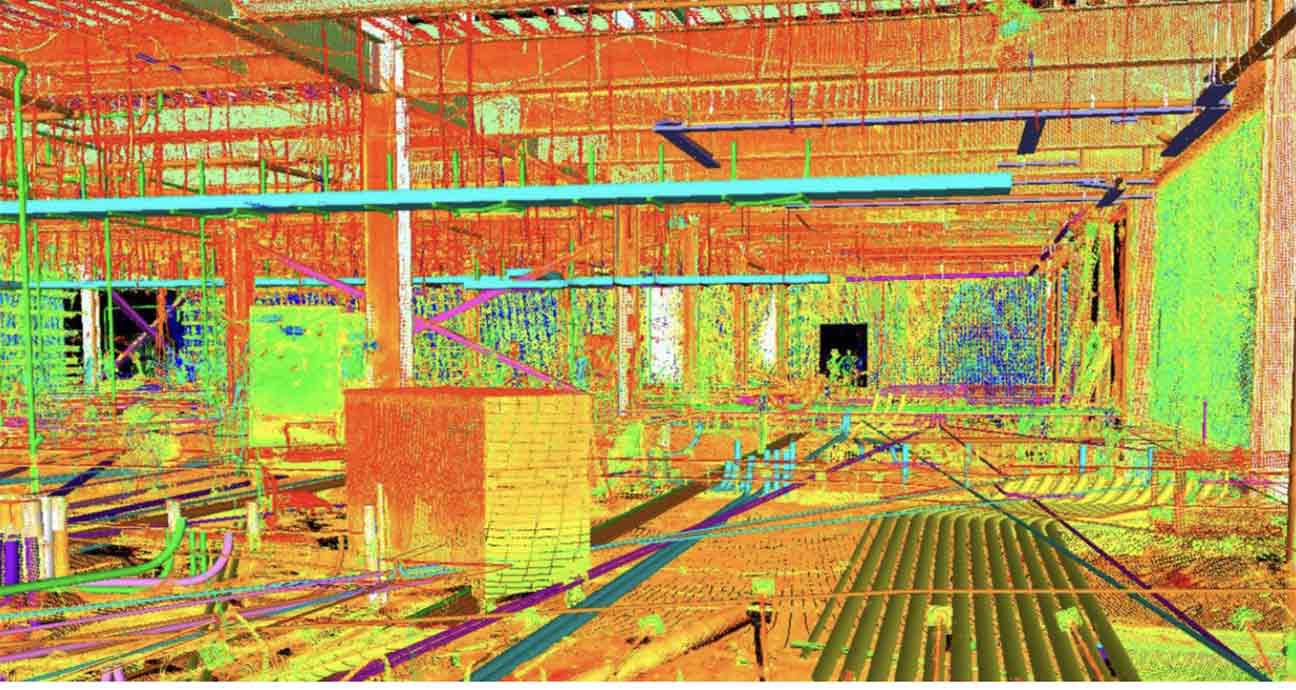
LiDAR services, photogrammetry, 3D building visualization, topographical mapping, bridge LiDAR scanning, geospatial analysis, terrestrial imaging, and bridge deflection inspection services are all provided by the reputable building and structural engineering asset integrity solutions provider EIWAA. Our cutting-edge non-contact laser imaging system, which replaces the conventional bridge health monitoring system, delivers accurate measurements of structural health monitoring and bridge rendering to determine the life expectancy of span, bridge structures, etc. Before, during, and after load testing events, dense 3D point clouds are created utilizing a high-speed 3D data capture laser scanner to enable all laser measurements.
EIWAA provides terrestrial scanning services that include topographical mapping, site scanning, ground LiDAR services, bridge lidar scanning, and geospatial analysis of bridges and mountains. Terrestrial laser scanning, photogrammetry, ground penetrating radar (GPR), GPS surveys, total station surveying, and unmanned aerial vehicles (UAVs) or drones are among our terrestrial operations. Terrestrial Scanning Services enables us to produce intricate, high-resolution models of habitats, structures, and terrain. We offer high-definition laser scanning services for ground-level scanning and terrestrial data collection. High-resolution 3D mapping creates terrain maps for terrain modeling and urban development. The LiDAR Surveying and Engineering team offers construction monitoring, site surveys, and as-built documentation services.