TOPOGRAPHICAL SURVEY SERVICES IN QATAR
We are one of the top Topographic Survey Companies in Qatar offers Topographical Survey Services by Total Station Survey, As-built Survey and land survey services, GPS Survey, Alignment survey and GPRS Survey services, Pipeline Survey, Underground utility survey and mapping services. As one of the best topographic survey services in qatar, we are providing Boundary survey, land survey, demarcation survey, setting out survey, land survey, land measurement survey services, GPS survey services and Ground Penetrating Radar Survey Services for underground utility surveying and mapping services.
As one of the utility survey companies in Qatar, we are providing Underground mapping Survey Services, GPR Mapping Services, GPR Survey Services and all types of construction Survey Services. EIWAA Oil and Gas Services is one of the top land surveyors in Qatar by providing Geodetic Survey, Cadastral Survey Services, Geographic Survey Services and Geographic Survey measurement Services in oil and gas as well as in commercial sectors.
GPS SURVEYING SERVICES IN QATAR
High precision data collection by topographical survey services mainly covers GPS Surveying services in Qatar along with GIS Mapping services, GNSS Surveying, Spatial Survey services and remote scanning services. Boundary survey services and digital mapping services shall be considered as land survey services in Qatar. We are one of the top GPS Survey service Company in Qatar involving the following services of,
- GPS Surveying services by placing a GPS Receiver at every project location
- Dynamic GPS Surveying services by shifting GPS Receiver for continuous data collection
- Real time monitoring and corrections by Kinematic GPS Surveying services from a base station
- Post processing kinematics to collect precise data
By Integrating data collection and analysis, we are providing Geographic Information Systems (GIS) Mapping Services.
GPRS SURVEY SERVICES IN QATAR
EIWAA is a leading GPRS and GPR survey company in Qatar that offers ground penetrating radar, electromagnetic surveying services and GPR investigation services. For accurate GPR data collection, analysis and processing, we offer GPR Mapping Services. Our Ground penetrating radar survey Services in Qatar used for utility mapping and underground utility survey services which helps to locate subsurface pipelines and wires. As a Ground Penetrating Radar Survey company in Qatar dealing with construction, mining, Petro chemical and Power Plants includes the following.
- Ground Penetrating Radar Survey Services: Focused on Nature Investigation services
- Subsurface Radar Survey: For assessing subsurface condition and its analysis
- GPR Mapping Services: Concentrated on mapping data collection through GPR survey
- Radar Survey: Providing Ground radar survey services.
- Non-destructive GPR Survey: To assess materials and structures, by the non-invasive assessment of the GPR Survey.
- Electromagnetic Survey: Using GPR Subsurface and electromagnetic waves with Ground penetrating radar
- Subsurface Imaging: Develop 3D Images by GPR Survey and its analysis
- Utility Survey: For underground utility survey and mapping services.
Total Station Survey
Pipeline Survey
Alignment Survey
Land Survey
Geospatial Survey
GPRS Survey
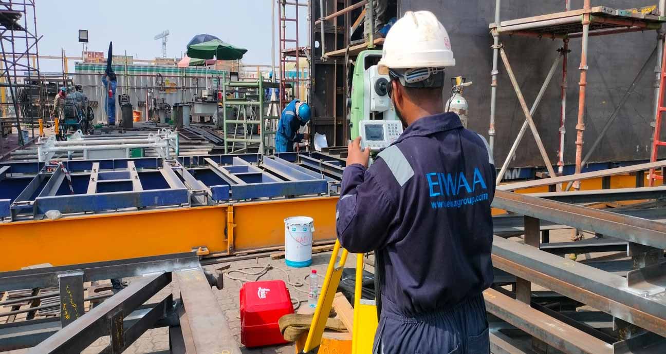
TOTAL STATION SURVEY SERVICES
Our Total Station Survey services in qatar using mainly at construction surveying sites for Land surveying and geotechnical surveying services along with as-built survey services. Method is creating elevation, plan, topographic contours and man-made structures. Following Total Station Survey services shall be used in construction and petrochemical fields,
- As-built Survey
- Construction Survey
- Geodetic Survey
- Alignment Survey
- Geotechnical Survey
- Alignment Survey
LAND SURVEY SERVICES
Our Land Surveying Services in Qatar provides various survey services for land development and construction projects. Land measuring services, land surveying services, boundary surveys and geographic survey services are all offered by our skilled land surveyors in Qatar. We can identify boundaries and mapping by measuring the physical characteristics of land through land surveying engineering. Our topographical surveyors provide precise information for mapping the land’s characteristics, plan, elevations, maps and contours.
UNDERGROUND UTILITY SURVEY AND UILITY MAPPING IN QATAR
EIWAA Surveying Engineering provides Underground Utility Surveying Services and Underground mapping services, Utility Mapping Services in Qatar. As a best land surveyors, we offers Geographic Survey Services, GPRS Survey services and GPR Survey to provide the underground utility survey and mapping services. Underground mapping survey covers utility mapping services for detecting underground utilities and buried pipeline routing.
- Utility Location Services: Focused on locating subsurface pipelines of gas, water, and electrical lines.
- Borehole surveys: Collect information on the materials and conditions in surface and buried surfaces.
- Geospatial Mapping Services: Creating spatial representations of subterranean features.
FREQUENTLY ASKED QUESTIONS
EIWAA Oil and Gas Services offers Engineering Survey Services for construction and Oil field by GPS Survey, GIS Survey and Topographic survey. Our Global Network covers the scope of 3D Laser Scanning Services, Building Condition Assessment, BIM Modeling etc. as per your needs.
Alignment survey is the term used to evaluate the linear and geometrical tolerances and dimensional control of an object or structure accurately by high precision surveying equipment.
As-built survey means survey of existing or present condition of an object in dimensional means for generating As-built drawing and modeling.
GPRS Survey or Ground penetrating Radar survey is used to identify underground utility survey and mapping, buried pipeline survey and underground pipeline routing.