
3D LASER SCANNING IN OMAN
If you are looking for PDO-approved 3D laser scanning services and reality capture surveying services from a top-tier 3D laser scanning company, please contact us. EIWAA delivers point cloud surveying, point cloud modeling, Scan-to-BIM solutions, and spatial scanning survey services required for oil and gas digital transformations of assets in power plants, petrochemical plants, and storage tank terminals. We provide advanced FARO and Leica industrial laser scanning solutions from our experienced reality capture specialists help develop building survey models, 3D imaging, and laser scanning dimensional inspection services. Our comprehensive point cloud management by skilled scan-to-BIM specialists processes point cloud modeling and digital twin solutions with engineering-focused deliverables.
EIWAA delivers fast, reliable and accurate 3D scanning solutions to support asset digitalization, facility management, and industrial transformation brownfield projects. Our 3D scanning services enable contractors and consultants to get accurate as-built information and as-built documentation without disrupting ongoing services. We digitalize the physical objects into precise digital assets to get as-built drawings, as-built models, and condition assessments.
INDUSTRIAL LASER SCANNING IN OMAN
Industrial Laser Scanning Solutions of power generation facilities, Airports, Hotels, Desalination plants and petrochemical refineries outcomes as-built drawing,3D models and as-built BIM models. Industrial laser scanning solutions by advanced 3D scanners and modeling software helps to get as-built documentation and accurate laser dimensional measurement for maintenance, repair and equipment installation for consultants, contractors and end users. This high-density point cloud survey and modeling, enables engineers to visualize the as-built conditions prior to installation of machines and equipment.
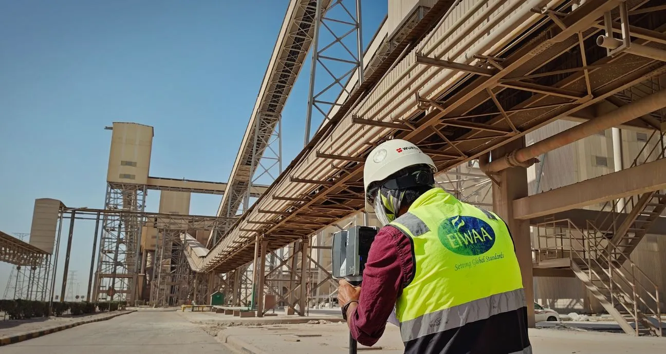
3D SCANNING IN OMAN
We are in the top list of 3D scanning companies that provide 3D imaging, 3D modeling, 3D rendering, architectural rendering, spatial scanning, and 3D visualization services. Building integrity inspection and structural assessment performed by using 3D scanners and 3D reality capture services. Unmanned Aerial Vehicles (UAVs)/drones, photogrammetry, 3D scanning, laser measurement services, and LiDAR scanning are all used in our digital surveying and mapping services.
We offer both ground-level scanning using HD laser scanning and terrestrial data collection services. To gather high-resolution spatial data on the earth’s surface and structures, our ground LiDAR surveying services use LiDAR methodology at ground level and are known as spatial scanning services. EIWAA offers 3D scanning services for asset management, facility management, inspection, and maintenance in the oil and gas, power plant, and refinery industries. The objective of these Scan2bim services is to use photogrammetry and spatial scanning to produce digital representations of physical features. For urban planning, development, environmental monitoring, and cultural heritage protection, our scanned spatial data significantly reduces project costs by saving time and accurate measurements.
BUILDING SCANNING IN OMAN
We create building models by high-precision building scanning and detailed engineering services. Detailed building scanning is necessary for building condition assessment and as-built documentation of commercial buildings, airports, hospitals, hotels, restaurants, and warehouses. The building scanning process includes the following, but is not limited to:
- Site Assess: The 3D scanning team visits the building to assess accessibility, identify the scanning positions, define the project scope, and establish control survey points.
- 3D Scanning: Millions of measurement points are captured from multiple locations at each level of building, and a point cloud survey and 3D scanning are conducted.
- Point Cloud Registration: Our Scan to BIM specialists combines scans into unified coordinate systems by software of Leica Cyclone, Autodesk Recap Pro, and FARO Scene.
- Scan data processing: The point cloud is processed to create as-built drawings, floor plans, elevations, sections, BIM models, and digital twin models.
- Scanning deliverables: 3D Scanning deliverable includes point cloud(E57,RCP,RCS), CAD Drawings, BIM Models, Asset registers and Digital twin models.
Our professional building scanning surveyors measure and create accurate floor plans, elevations, sections, and floor plan layouts for any kind of building. All the building scanning data are converted into customized formats of point clouds, 3D CAD drawings, BIM models, and digital twins for engineering and construction contracting companies.
3D Laser Scanning
LiDAR Scanning
3D Modeling
3D Imaging
3D Mapping and Surveying
Photogrammetry
REALITY CAPTURE SERVICES IN OMAN
If you are planning a repair, renovation, extension, and maintenance of brownfield engineering and Scan-to-BIM projects, we are the Scan-to-BIM consultant for oil and gas facilities, storage tank terminals, and power and utility facilities. All the oil and gas contracting companies invest in reality capture services for getting accurate existing condition data, improved safety, and better design coordination. The workflow of reality capture services includes
- Project Planning: Identify the scope, accuracy requirements, level of detail, and client deliverables.
- Site Control Survey: Site control points to ensure accurate positioning and georeferencing.
- Data Capture: Millions of spatial measurements by Leica RTC 360, FARO Focus Premium, and 360 imaging platforms.
- Point Cloud Registration: Point cloud registration by advanced software such as Leica Cyclone, Autodesk Recap Pro, and FARO Scene.
- Data Processing and Modeling: Registered point cloud converted to as-built drawings, CAD models, BIM models, digital twins, and asset information models.
We provide reality capture measurement services for accurate as-built data for plant modifications, facility upgrades, building renovations, and expansion projects.
POINT CLOUD SURVEY IN OMAN
The point cloud survey is a 3D laser capture and surveying method for a number of measurement points within a minute through spatial scanners and 3D scanners. A point cloud survey is a detailed digital representation of existing buildings, structures, and assets. We provide point cloud surveys of buildings and assets at sites for making 3D models, engineering design, asset management, scan-to-BIM, and as-built drawings. Most of the contracting companies approach us for accurate existing condition assessments of buildings and structures prior to the major renovation or expansion projects.
Prior to the Scan-to-BIM projects of buildings, bridges, and airports, we create models of architectural BIM, structural BIM, MEP BIM, and facility management. Point cloud surveys are applicable for buildings; storage tank terminals; airports; hotels; restaurants; universities; and industrial facilities such as warehouses, processing plants, and manufacturing units.
POINT CLOUD SCANNING IN OMAN
Get accurate point cloud scanning services with deliverables of as-built drawings, floor plans, sections, elevations, BIM models, and digital twin models from a 3D scanning company. If you are looking for a professional point cloud survey service, we provide high-accuracy point cloud scanning and 3D imaging solutions with multiple branches across the regions. Using industry-leading software for point cloud scanning, we deliver accurate point cloud datasets and raw data, including E57 files, LAS files, XYZ files, and RCP/RCS files.
3D IMAGING IN OMAN
Get professional and accurate 3D imaging services for visualization of your assets and digital transformation in engineering, construction, infrastructure, oilfield, and industrial sectors. Our 3D imaging services are used to visualize, analyze, measure, and document industrial plants, infrastructures, and storage terminals. 3D imaging is applicable for engineering measurement, facility visualization, as-built documentation, reality capture measurements, and construction verification services.
For the maintenance and renovation requirements of accurate as-built documentation,3D Imaging used for equipment layout verification, plant modification planning, facility management, and Digital asset management.
LASER SCANNING INSPECTION IN OMAN
We provide quality inspection and certification, especially laser scanning inspection in oil and gas fields where human access is not possible. Oil and Gas: Laser scanning inspection includes inspection and certification for storage tanks, pipelines, and pressure vessels. For as-built drawing preparations, API inspection services require ovality, roundness, straightness, peaking/banding surveys, alignment surveys, etc. Laser scanning inspection is mandatory.
We provide building laser scanning inspection services to get CAD models, BIM models, and as-built drawings for building condition assessment and dilapidation survey reports, assisting building contractors, consultants, and real estate companies.
FREQUENTLY ASKED QUESTIONS
LiDAR, or light detection and ranging technology, is used to create point clouds for 3D modeling by 3D scanning an item or structure.
Our digital surveying and mapping services for urban planning, construction, and development use LiDAR scanning, photogrammetry, laser measuring services, and Unmanned Aerial Vehicles (UAVs)/Drones.
Photogrammetry is the process of extracting and creating 3D detailed information from photos