
TOPOGRAPHICAL SURVEY SERVICES IN OMAN
We are one of the top Topographic Survey Companies in Oman offers Topographical Survey Services by Total Station Survey, As-built Survey and land survey services, GPS Survey and GPRS Survey services, Pipeline Survey, Underground utility survey and mapping services. For accurate as-built measurements of existing buildings and construction, EIWAA Oil and Gas Services offers topographic survey and GPS Survey Services by using Total Station Survey, Underground Mapping Surveying, As-built surveying services and Alignment Survey services. As one of the best topographic survey companies in oman, we are providing Boundary survey, land survey, demarcation survey, setting out survey, land surveying services, land measurement survey services, GPS survey services and Ground Penetrating Radar Survey Services for underground utility surveying and mapping services.
As one of the utility survey companies in Oman, we are providing Underground mapping Survey Services, GPR Mapping Services, GPR Survey Services and all types of construction Survey Services. EIWAA Oil and Gas Services is one of the top land surveyors in Oman for providing Geodetic Survey, Cadastral Survey Services, Geographic Survey Services and Geographic Survey measurement Services.
GPS SURVEYING SERVICES IN OMAN
High precision data collection by topographical survey services mainly covers GPS Surveying services in Oman along with GIS Mapping services, Spatial Survey and Scanning services, Geodetic survey and As-built Survey services. Boundary survey services and digital mapping services shall be considered as land survey services. We are one of the top GPS Survey Company in Oman involving the following services of,
- Static GPS Surveying services by placing a GPS Receiver at each project locations
- Kinematic GPS Surveying services by shifting GPS Receiver for continuous data collection
- Real time corrections by Kinematic GPS Surveying services from a base station
- Post processing kinematics to gather accurate data
In Boundary survey services, property line and corners confirm to the legal boundary is important in land survey. Integrating data collection and analysis; we are providing Geographic Information Systems (GIS) Mapping Services.
GPRS SURVEY SERVICES IN OMAN
EIWAA is a leading GPRS and GPR survey company in Oman that offers ground penetrating radar, electromagnetic surveying services and GPR investigation services. For accurate GPR data collection and analysis, we offer GPR Mapping Services in Oman. Our Ground penetrating radar survey Services in oman used for utility mapping and underground utility survey services which helps to locate subsurface pipelines and wires. As a Ground Penetrating Radar Survey company in Oman dealing with construction, mining, Petro chemical and Power Plants includes the following.
- Ground Penetrating Radar Survey Services: Focused on Nature Investigation
- Subsurface Radar Survey: For assessing subsurface condition
- GPR Mapping Services: Focusing on mapping data collection through GPR survey
- Radar Survey: To provide Ground radar survey services.
- Non-destructive GPR Survey: To assess materials and structures, by the non-invasive component of the GPR Survey.
- Electromagnetic Survey: Using GPR Subsurface and electromagnetic waves with GPR
- Subsurface Imaging: Developing Images by GPR Survey and analysis
- Utility Survey: For identifying underground utilities and mapping services
Total Station Survey
Pipeline Survey
Alignment Survey
Land Survey
Geospatial Survey
GPRS Survey
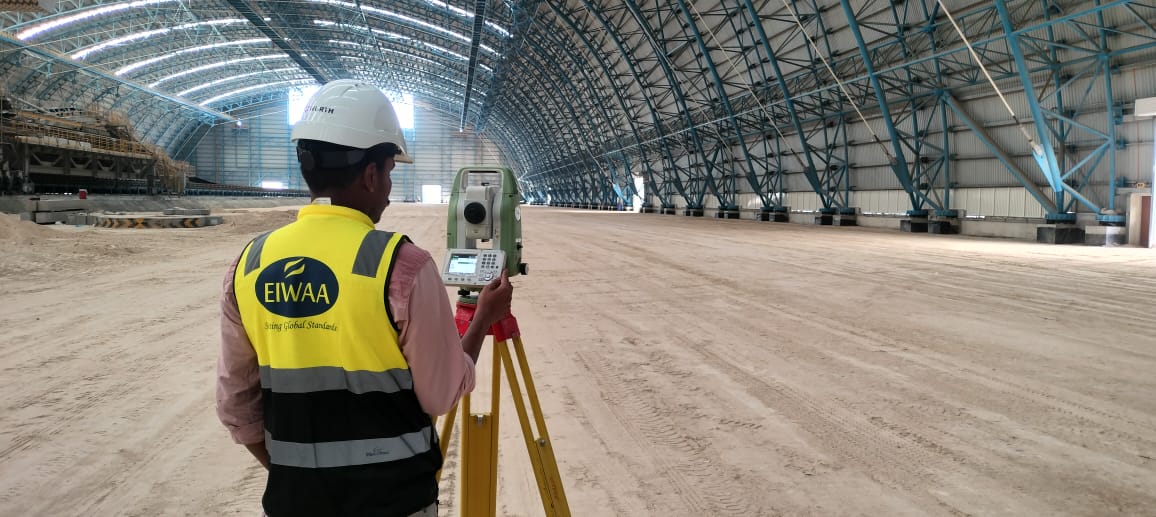
TOTAL STATION SURVEY SERVICES
Our Total Station Survey in oman using mainly at construction surveying sites for Land surveying and geotechnical surveying services along with alignment survey and as-built survey services. Method is creating maps of elevation and other topographic contours and man-made structures. Following Total Station Survey services shall be used in in mining, construction and petrochemical fields,
- As-built Survey
- Construction Survey
- Geodetic Survey
- Alignment Survey
- Geodetic Survey
- Geotechnical Survey
- Remote Sensing and GIS Survey
For site preparation and construction layout preparations, initial site surveying services of control point survey and as-built surveying services are applicable.
LAND SURVEY SERVICES
EIWAA Engineering Survey provides Land Surveying Services in Oman for a various land development and construction projects. Land measuring services, land surveying, boundary surveys and geographic survey services are all offered by our skilled land surveyors in Oman. We can identify boundaries and mapping by measuring the physical characteristics of land through land survey services. Our topographic surveyors provide accurate information for mapping the land’s characteristics, elevations, maps and contours.
UNDERGROUND UTILITY SURVEY AND UILITY MAPPING IN OMAN
EIWAA Surveying Engineering provides Underground Utility Surveying Services covers Underground utility survey, Utility Mapping Services by Ground Penetrating Radar Survey Services in Oman. As a best land surveyors in Oman, we have Geographic Survey Services, GPRS Survey services and GPR Survey to provide the underground utility survey and mapping. Underground mapping survey services includes utility mapping as well as GPRS Survey services for detecting underground utilities and buried pipeline routing.
- Utility Location Services: Focused on locating subsurface gas, water, and electrical lines.
- Borehole surveys: gathering information on the materials and conditions in surface and buried surfaces.
- Geospatial Mapping Services: Focused to create spatial representations of subterranean features.
FREQUENTLY ASKED QUESTIONS
EIWAA Oil and Gas Services offers Engineering Surveying Services for construction and Oil field by advanced Surveying Services of GPS Survey, IS Survey and Topographic survey. Our Global Network covers the scope of 3D Laser Scanning Survey, Building Condition Assessment, BIM Modeling etc. as per your needs. Data collection, Evaluation analysis, and interpretation pertaining to the earth’s surface and man-made features are all included in our geospatial survey services in Oman. Remote sensing measurement services, GPS survey/global positioning system and GIS surveying services, are all included in topographic survey services. Urban development planning, environmental monitoring, road and bridge deflection survey evaluation, and public utility control all make use of our accurate topographical survey services in Oman.
Total Station Survey is used to measure Angle, Distance and Coordinate Measurement by trigonometrical analysis and provide accurate measurements. Total Station Survey used in storage tank terminals for tank settlement survey services.
A condition survey is essentially a visual examination approach used by a skilled building surveyor to gather information about the plumbing, mechanical, electrical, and physical conditions of a building. A complete engineering study of a building's as-built condition, including its physical structure, wear and tear, furnishings etc. is called a dilapidation survey.
MEP survey means survey of mechanical, Electrical and Plumbing equipment in a building and it is also known as building survey. Through Total station Surveying Services, we measure angles and distance by electronically and process by trigonometrical rules. Theodolite is a mechanical or electronic instrument with less features of total station.