
SCAN TO BIM SERVICES IN UAE
EIWAA is the top Scan to BIM Services in UAE providing scan2bim solutions, Terrestrial scanning, Topographic mapping, structural assessment of bridges,Scan to CAD,CAD design and drafting services in Dubai and Abudhabi. We offer 3D LiDAR surveying, engineering surveying, and topographical surveying as a 3D surveying company in the United Arab Emirates. services for point cloud surveying and LiDAR data collection. The services offered by Scan to BIM Solutions in the United Arab Emirates include Survey to BIM, Scan2bim, Scan to CAD, Scan to BIM, Point cloud to BIM, and more. 3D laser scanning, data processing, BIM modeling, integration with pre-existing models, documentation and analysis, Scan2bim services, BIM collaboration, and BIM coordination are all included in our Scan to BIM services. Scan to BIM Solutions in the United Arab Emirates is the process of using 3D laser scanning or photogrammetry to transform physical structures into digital data and 3D models. Physical structures may building structures, infrastructures, Onshore and offshore buildings, facilities, hotels and restaurants etc.
TERRESTRIAL SCANNING SERVICES IN UAE
EIWAA provides terrestrial scanning services in the United Arab Emirates, including topographical mapping, site scanning, ground LiDAR services, bridge lidar scanning, and geospatial analysis of bridges and mountains. Unmanned aerial vehicles (UAVs) or drones, photogrammetry, GPS surveys, total station surveys, ground penetrating radar (GPR), and terrestrial laser scanning are some of our terrestrial activities. High-resolution, detailed representations of environments, structures, and terrain can be created through Terrestrial Scanning Services. We are taking pictures of buildings or other things at ground level is part of terrestrial photogrammetry and terrestrial imaging services.
We offer high-definition laser scanning services for ground-level scanning as well as terrestrial data collection. Our ground LiDAR Services collects high-resolution spatial data on the earth’s surface and structures by using LiDAR technology at ground level. 3D maps of the terrain are created through high resolution 3D mapping for use in landscape modeling and urban planning. Site surveys, construction monitoring, and as-built documentation services are provided by the LiDAR Surveying and Engineering team. Our Scan2BIM Services and Terrestrial Scanning Services includes but not limited to,
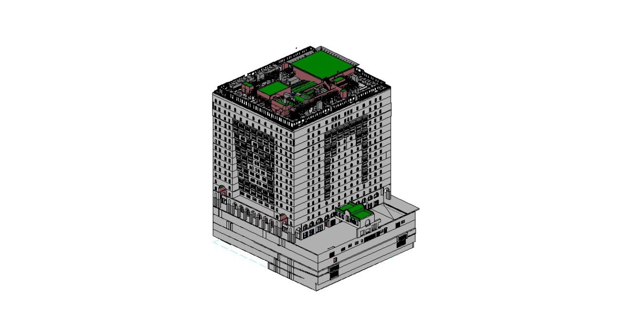
- 3D Laser Scanning: High-precision LiDAR scanners are used to collect data and generate point clouds that precisely represent the sizes and spatial connections of structures.
- Point Cloud data processing: Data registration for Point cloud to BIM services must be done using sophisticated 3D software.
- BIM Modeling: 3D modeling is the process of creating a 3D BIM model utilizing advanced software.
- BIM Integration: We are updating current BIM models with current conditions and ensuring precise as-built representations as a scan to BIM solutions in the United Arab Emirates.
- BIM Documentationand BIM analysis: 3D visualization, geospatial analysis, design development, and BIM documentation services are all included in BIM documentation and analysis.
- BIM Collaboration and BIM Coordination: Our Experienced BIM engineers collaborate and coordinate BIM services from Point cloud to BIM, Scan to BIM, and Scan-to-Model.
Scan to BIM Solutions
3D Visualization
Mountain Terrain Modeling
Structural Assessment of Bridges
Point Cloud to BIM
LiDAR Survey
TOPOGRAPHIC MAPPING
The process of creating intricate 3D maps of the landscape, including contours, elevations, and landforms is known as topographic mapping services. Services for topographic mapping include boundary and land use analysis, elevation changes, terrain analysis and GIS integration.We offer structural 3D assessment of bridges, bridge modeling and analysis and bridge LiDAR scanning through our Topographic Mapping of 3D Bridge Imaging Services. Our dedicated bridge topographic mapping services creates bridge point clouds to BIM Model.
CAD DESIGN AND DRAFTING
We use computer-aided design (CAD) design services UAE to create precise technical drawings, blueprints, floor plans, and 3D models. Topographical surveyors, pipeline integrity inspection engineers, heritage BIM services and plant design and modeling services are all aided by our CAD design services. Our CAD engineers with expertise in CAD design services have experience with plant design modeling, CAD to BIM conversion, and PDF to CAD conversion.
We offer CAD conversion services in the UAE that have been proved to work, including rendering image to CAD conversion, autoCAD to archiCAD conversion, hand drawings to CAD conversion, and paper to CAD conversion. For architectural, HVAC, electrical, firefighting, MEP, and topographic drawings, we offer complete AutoCAD conversion services. We help the civil, construction, and engineering industries with all technical drawing services, including 2D and 3D modeling, blueprint design, and virtual drafting.
FREQUENTLY ASKED QUESTIONS
We provide 3D mapping, 3D visualization, visual data capture, terrestrial imaging, and reality capture as part of our photogrammetry surveying services in UAE . Maps and 3D models of real-world objects and structures are produced using photogrammetry services.The two categories of photogrammetry services that we offer are terrestrial and aerial photogrammetry. Our remote sensing surveying services cover all aspects of surveying and mapping solutions, including image-based surveying, 3D mapping, 3D visualization, and mapping, among other things. Drone surveying services that capture visual data are utilized for both terrestrial and geospatial imaging services.
Topographic Mapping Services of Bridges, Mountains and Structures.
- Initial Concept Stage (LOD 100): Conceptual parameters and basic detailing
- Schematic Design(LOD 200):Convert conceptual drawings into structural design using schematic design.
- Detailed Design(LOD 300):It is a refined structural design that includes precise measurements.
- Construction stage Detailing (LOD 400):Convert design into intricate structures at the construction stage.
- Asbuilt Detailing(LOD 500):The quality degree of detailing is related to as-built detailing (LOD 500).