
STOCKPILE SURVEY SERVICES IN UAE
EIWAA is one of the top stockpile survey services in UAE for providing stockpile measurement survey, Aggregate Quantity Survey, Earthworks Survey, Stockpile Quantity Survey Services and storage tank dimensional survey by laser measurement services. EIWAA Oil and Gas Services is the stockpile survey services in UAE for providing stockpile measurement survey, Aggregate Quantity Survey, Earthworks Survey and Stockpile Quantity Survey Services by laser measurement services. EIWAA Stockpile Survey services by laser measurement is the top quantity survey service in UAE for stockpile volume survey, stockpile quantity surveys and earthwork surveys. Stockpile quantity survey Services in UAE involve the accurate measurement and as-built survey of aggregates, coal, or minerals. For accurate stockpile quantity survey in UAE, we are providing stockpile measurement survey by LiDAR 3D laser scanning and GIS Survey. Earthworks Survey and Stockpile measurement survey relate to each other, and it shall be performed by accurate 3D scanner and terrestrial scanner with advanced 3D Modelling software.
More precise and effective quantity surveying services and estimation for earthworks projects are made possible by the combination of 3D scanning technology with GIS. For earthwork surveys, stockpile volume surveys, and stockpile quantity surveys, EIWAA Volumetric Survey Services is the best quantity survey company in UAE. Accurate volume calculation, stockpile volume survey, earthworks survey and quantity survey services are critical for project bidding and execution in the mining and construction sectors. LiDAR scanning and Geographic Information Systems (GIS) services in UAE provide more precise estimating for earthworks, quantity surveying and stockpile volume surveys.
AGGREGATE QUANTITY SURVEY SERVICES
The location and distribution of possible natural aggregate deposits should be studied using our remote sensing and aerial geophysical measurement services, which is used to identify and mapping exposed bedrock units and surficial deposits. The distribution of bedrock units has been mapped using geophysical techniques including aeromagnetic and gamma-ray spectroscopy, which should also be helpful in locating some bedrock units that can be used for crushed stone. Based on changes in resistivity regulated by porosity, permeability, and the enclosed fluids, aerial resistivity surveys have been utilized to map surficial deposits. Both compositional data based on physical attributes and spatial information detailing the surface features are included in the data obtained from these observations. Digital measurements are gathered by remote sensing equipment and can be readily integrated into Geographic Information System databases after being processed, examined, and interpreted by computer methods.

Remote Sensing measurement
Geophysical measurement
Digital Measurement
3D Mapping and Surveying
Laser Measurement
Volume Calculation
EARTHWORKS SURVEY SERVICES IN UAE
The process of precisely measuring and tracking the movement of soil, bedrock, and materials on a building site is known as earthwork volume monitoring. This helps to effectively manage costs and schedules by ensuring that excavation, filling, and grading operations are in line with project specifications and progress. For applications in surveying, mapping, and 3D modelling, georeferenced point clouds—sets of 3D data points collected from actual locations and precisely fit to geographic coordinates—allow for an accurate spatial representation of physical objects, terrain, or structures. Bare earth surfaces, which are often employed in geospatial analysis and surveying to accurately depict the Earth’s topography, are natural or terrain ground conditions that are free of any plants, buildings, or man-made structures.
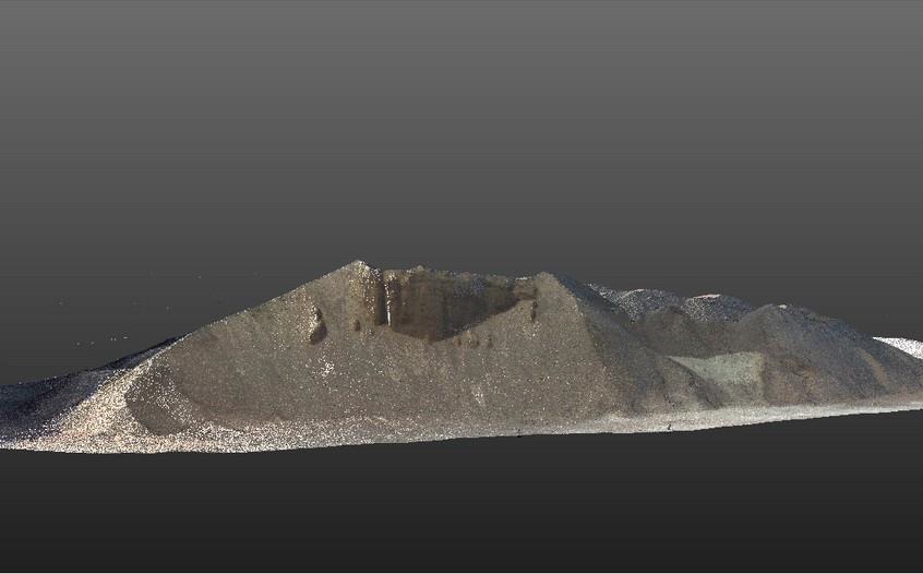
VOLUMETRIC SURVEY SERVICES IN UAE
We are one of the Stockpile Volumetric Survey Services and Finished Goods Survey company in UAE for conducting survey reconnaissance of the entire stockyard and establish survey control stations. Our Volumetric survey in processing plants using bulk cargo survey using 3D Laser scanner to obtain identification of the cargo for each stockpile and considering the cargo density, we can determine cargo volume survey services for each stockpile. Volumetric Survey of physical stock measurement services for Clinker and other raw materials includes lime stone, sand, normal clay, white clay ,Iron ore and high free lime.
LASER MEASUREMENT SERVICES
Our Laser measurement services include storage tank peaking/banding survey, verticality checking and measurement, roundness survey, ovality measurements and more. Laser measurement services can be provided by 3D Laser scanning and LiDAR Scanning technology by using EODR Laser measurement techniques. It is a remote sensing and non-contact dimensional measurements for all types of storage tanks including floating roof storage tanks, Internal floating roof storage tank and fixed roof type storage tanks.